Lesson 1 - Clues to Human Migration
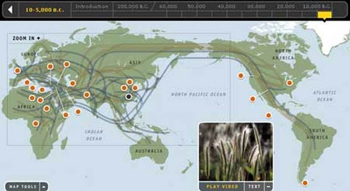
How do we know what routes humans took as they migrated around the world?
In this lesson students Imagine they are detectives and figure out ways to solve the myustery of how humans migrated around the wold.
In this lesson students Imagine they are detectives and figure out ways to solve the myustery of how humans migrated around the wold.
|
Directions:
1. Have students put themselves into the detective shoes. Tell students to imagine that someone has hired them to track down a missing person. What steps would they take to find them? 2. Discuss the mystery of the genographic project. Scientists are looking for clues to understand how our ancestors migrated from Africa, humans evolved, and moved to other continents. Have students look at a map of the World today. Ask them: What continents do humans live on today? Have humans always lived there? Where did humans evolve? How did humans come to populate the entire world? 3. Divide students into detective teams. Give each team a map of the world and a timeline. Have students try to determine: When humans left Africa, where they migrated first, what routes they took, 4. Discuss students ideas about how to solve the migration issue If students have not mentioned, tell them about DNA like scientists use to determine human migration patterns 5. Students finish class with a 10 minute video on the Genographic Project. |
Standards: National Council for Social Studies Curriculum Standards • Theme 3: People, Places, and Environments National Geography Standards National Geography Standards • Standard 3: How to analyze the spatial organization of people, places, and environments on Earth's surface • Standard 9: The characteristics, distribution, and migration of human populations on Earth's surface National Science Education Standards National Science Education Standards • (9-12) Standard A-2: Understandings about scientific inquiry National Standards for History National Standars for History • World History Era 1 (5-12) Standard 1: The biological and cultural processes that gave rise to the earliest human communities |
Lesson 2 - Using Genetic Markers to Create Lineages
How do genetic markers help us identify lineages?
In this lesson students do an activity in which they build a trail of genetic markers through several generations to create a tree showing the relatinships among descendents.
In this lesson students do an activity in which they build a trail of genetic markers through several generations to create a tree showing the relatinships among descendents.
|
Directions:
1. Brainstorm lists of inherited family traits Take a poll. Ask students how many of them can raise just one eyebrow and not the other. Then ask how many can wiggle their ears. Ask how many can curl their tongues. Not all students will be able to do all three things. Ask: Can you guess why some of us can do these things and others cannot? Explain that these specialized skills are inherited. Have students brainstorm other traits that we inherit from our parents and grandparents. Write their answers on the board, sorting them into different categories. 2. Tell students they are about to play a game that will help them understand the process of genes and mutations in human DNA over time. 3. Divide students into 4 groups. Give each group one set of colored markers, 50 index cards, and the descendent randomizer worksheet http://education.nationalgeographic.com/media/file/406_descendant_randomizer.pdf Have students cut out the numbers, fold them, and put them into a cup or hat. 4. Complete round one Tell each group to:
4. Complete round two. Tell each group to:
5. Complete round three. Tell each group to:
6. Complete rounds 4-10 Tell each group to repeat the steps in round three, recording each new round number on the back of each descendant card, until they have 15-20 cards in the final round. 7. Record the results. Have each group draw their group's family tree on a piece of paper, using lines to connect each descendant to its ancestor. Have students draw lines around groups of descendants with the same symbols, or genetic markers. Explain that these represent lineages—groups of people that descended directly from the same ancestor. Ask: Do all descendants of a particular individual inherit the same genetic markers? Explain. Have students try tracing several descendants on the bottom line back to their original ancestor. Discuss how the genetic markers enable them to do this. |
Connections to National Standards National Council for Social Studies Curriculum Standards • Theme 3: People, Places, and Environments National Geography Standards • Standard 9: The characteristics, distribution, and migration of human populations on Earth's surface National Science Education Standards • (9-12) Standard C-3: Biological evolution 
|
Lesson 3 - Mapping our Human Footprint
What connection can you make between patterns of human influence
and geographic factors?
In this lesson students learn about human footprint data and analyze a map showing where humans have influences the earth.
and geographic factors?
In this lesson students learn about human footprint data and analyze a map showing where humans have influences the earth.
|
Directions:
1. Introduce Tell student that scientists mapped degrees of human influence over every square kilometer of Earth's surface.Four factors that were evaluated were: population, land routes, travel use, and lights. While humans affect Earth in many ways, these four have the most immediate impact on wildlife and wild lands. Ask: Why do you think these four factors have the most immediate impact? 2. Display the Human Footprint data layer on the interactive map. Display the interactive map with the Human Footprint layer selected. Click on the "i" symbol and review the legend. Explain that green signifies areas least impacted by humans. Purple signifies areas most impacted by humans. Ask: What is the predominant color in North America? What level of impact does it signify? Invite volunteers to point out any patterns they notice, such as greater human impact near urban areas. 3. Have students make a personal connection. Ask students to find their hometown. Ask: What color is it on the map? How great is the human impact? 4. Discuss areas of lesser and greater human impact 6. Have students compare the Human Footprint data layer and the Population Density data layer on the interactive map. |
Connections to National Standards National Geography Standards • Standard 14: How human actions modify the physical environment |
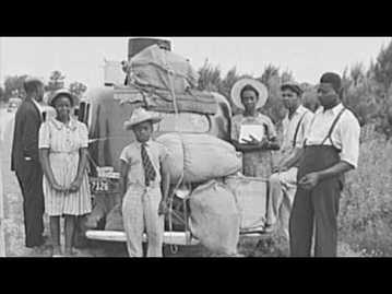
Lesson 4 - Exploring Modern Human Migrations
What are some causes of modern human migrations?
In this lesson students will research the causes of several modern migrations, and create a map showing these migration routes.
In this lesson students will research the causes of several modern migrations, and create a map showing these migration routes.
|
1. Introduce the topic of modern human migrations.
Review some of the causes of ancient human migrations. Ask: Are humans still migrating today? What are some examples of migrations that took place in the last few hundred years? Record students' ideas on the board. Ask: Do you think these modern migrations differ from ancient migrations? How? Discuss and list possible differences such as cause, distance, duration, and method of travel. 2. Assign research topics. Divide students into small groups of four or five. Assign each group a modern migration to research, use the handouts provided in this activity. Select from the following modern human migrations:
Distribute the readings for assigned migrations to each small group. Ask students to read about the modern migration assigned to their group and take notes on the following questions:
4. Have students discuss their findings. Have each group display their map and give a report on their findings. As each group reports, make a list on board of reasons for the migrations, and a list of challenges humans faced during the course of their migrations. 5. Relate the findings to the Genographic Project. Point out that some humans on these modern migrations probably carried genetic markers with them, just as humans on ancient migrations did. |
Connections to National Standards IRA/NCTE Standards for the English Language Arts • Standard 7: Students conduct research on issues and interests by generating ideas and questions, and by posing problems. They gather, evaluate, and synthesize data from a variety of sources (e.g., print and nonprint texts, artifacts, people) to communicate their discoveries in ways that suit their purpose and audience. National Council for Social Studies Curriculum Standards • Theme 3: People, Places, and Environments National Geography Standards • Standard 3: How to analyze the spatial organization of people, places, and environments on Earth's surface • Standard 9: The characteristics, distribution, and migration of human populations on Earth's surface Handouts & Worksheets Websites 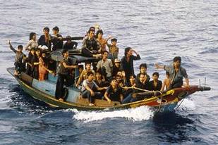
|
Lesson 5 - The Debate Over Globalization
What are the pros and cons of globalization?
In this lesson, students research, analyze, and debate the pros and cons of globalization.
In this lesson, students research, analyze, and debate the pros and cons of globalization.
|
Directions:
1. Introduce globalization. Explain to students that globalization means a more connected world. Globalization is the movement and integration of goods and people among different countries. Globalization is driven by international trade and aided by information technology. Make sure students understand that there are pros and cons to globalization, all of which have economic, social, political, and cultural impacts. Ask them to brainstorm what some pros and cons may be, and write them on the board. 2. Distribute the worksheet and have students research globalization. Distribute copies of the worksheet Decision Matrix to each student. Have students use the provided websites to conduct their own research and to learn more about the issues in the debate over globalization. They can also find resources at the school library or a local library. Ask students to record the information they find on the worksheet. Handouts & Worksheets 3. Have students decide what they think about globalization. Based on their research, tell students to select the arguments that they believe are most valid. 4. Have students write about globalization. Have students write a bulleted list of information that supports the views they selected. Tell students they can choose one aspect of globalization, such as economic costs and benefits, or they can look at the issue as a whole. 5. Have students debate globalization. Divide the class into two groups: students who focused on pros and students who focused on cons. Have the two groups debate the issue. Make sure students back up any statements with factual information from reliable resources. |
Websites for student research on globalization
Connections to National Standards National Geography Standards • Standard 11: The patterns and networks of economic interdependence on Earth's surface Voluntary National Content Standards in Economics • Standard 3: Allocation of Goods and Services: Different methods can be used to allocate goods and services. People acting individually or collectively through government, must choose which methods to use to allocate different kinds of goods and services. |
Lesson 6 - Guess the Place
What characteristics help you identify the place of an ancient civilization?
|
1. Write the names of civilizations and major physical features from the ancient civilizations on a map you are working with on separate index cards.
Create one index card for each student. Tape one of the index cards to each student’s back. 2. Select a player to go first and have him or her stand in front of the group. Select a player to go first. The player cannot see the place written on their card, but the rest of the students can. 3. Have the rest of the students refer to a map to familiarize themselves with the place. Have students consult one of the large maps from the MapMaker Kit you are working with to pinpoint the location of the item on the player’s index card. Make sure the map is available so students can answer the player’s questions correctly; however, the player should not be able to see the map. 4. Have the player guess the place on their card. The player must guess what the place is by asking geographic questions with “yes” or “no” answers. For example: Am I in South America? (yes) Am I on the West coast? (yes) Am I a river? (no) Am I a country? (yes) Am I long and skinny? (yes) Correct answer: Chile. 5. If the student has not identified their place correctly after a predetermined time, allow the rest of the class to offer hints. Provide a time limit; for example, three minutes. After that, allow the group to help the player by using the map to give hints until the player either guesses or cannot answer correctly. 6. Continue the guessing game. Have each student take a turn as the player, if time allows. |
Connections to National Standards National Geography Standards • Standard 4: The physical and human characteristics of places |
Resources:
http://education.nationalgeographic.com
http://jbid.com
http://pbseducation.org
http://pointwrite.blogspot.com
http://unhor.org
http://jbid.com
http://pbseducation.org
http://pointwrite.blogspot.com
http://unhor.org
